The city of Hamilton's Official Plan identifies specific communities that are areas with an important concentration of services, shops, residential uses and other facilities which serve as a focal point for the surrounding community.
They are intended to have a mix of uses that allow for access to housing, employment, services and recreation in close proximity to each other and transit.
The Node study is being conducted in parallel with the 'Waterdown Built Heritage Inventory' study and will help inform the Plan policies and the development of urban design guidelines that will guide future change and development in the village of Waterdown.
For more details on the secondary plan go to the link "Community Node Secondary Plan Study' - CLICK HERE
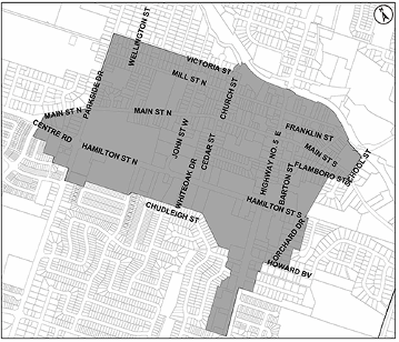
See the nodestudy area at right...
The study area extends west to east along Dundas St. from the lands across from Redcliff Court to the Canadian Pacific Railway line/Grindstone Creek and north to south from Nisbet Blvd. to the southerly end of Hamilton Street. The area includes approximately 112 hectares of land.
INTERIM CONTROL BY-LAW
As part of the Secondary Node Plan, On May 20, 2020, Council passed two interim Control By-Laws, The by-laws apply to the study area and also additional residential lands adjacent to the study area. The Control By-Laws will allow for planning studies to be completed for the area.